

Rebranding Indianapolis
Getting it Known About as the Greenway Capital of the World
Indianapolis - Always a Leader
Gateway to the West with its National Road wood covered bridge to the frontier where there were no roads, beg. 1834
First train station in the world to act as a hub for all train lines, beg. 1852
Known as the Railroad City of the West, its train station connected the East to Chicago and the transcontinental railroad for passengers on their way to San Francisco with as many as 200 trains a day
Invented Meat Locker refrigeration, George Stockman of Kingan Pork (now the central part of White River State Park), 1868
Before refrigerated rail cars shipped beef at the end of the 19th Century, Indianapolis dictated what Americans ate by being this country’s largest pork (which could be preserved by salt) producer and shipper
Parry Manufacturing Co - world’s largest cart, wagon and carriage making plant, 1885
Stronghold for some of America’s very first HiWheel bicycles, 1890’s
Gave its many bicycle clubs (about 100) a prominent voice in road use policy (by 1890, there were over 105,000 people in Indianapolis)
Home to Diamond Chain, one of the leaders of the Industrial Revolution. Diamond made equal sized wheel bicycles and automobiles affordable for the masses. In making it possible for motors to do more than spin, they also made the assembly line possible as well as the Wright Bros Flight and then air travel, beg. 1890
Birthplace of automobile manufacturing, once home to 97 different car manufacturers, more than any city in America
Home to largest street car system in the world, 1890 - 1953
Home to Presto-O-Lite, which made it possible for Americans to drive when it got dark, beg. 1906.
Birthplace of the automobile showroom, 3-story Fisher Automobile Co. (now a Kroger/apt complex) 1909
Birthplace of the first auto mall/row (where people from all over the USA could come to get their automobile needs serviced from paint to brakes, upholstery, tires, bodywork and etc.) in the world, Michigan to 10th on Capitol Ave, 1909
Home to first automobile test track in the world, the Indy 500 Motor Speedway, 1909
Birthplace of the Lincoln Highway, first coast-to-coast car road, New York to San Francisco, in the world, 1914
First and only US city to host the PanAm Games, 1987
Home of Ray Irvin’s actualized Greenway Master Plan (396/sq. mi.), beg. 1993
Greenway Capital of the World
Home to the first downtown Greenway on the Planet, the Indianapolis Cultural Trail, 2013
“The late eighties and the nineties, and the early years of the new century, were the best years, and Indianapolis the best place. Here were the fine restaurants, the celebrated bars; here were the brawl and bustle of commerce and industry; here were the magnificent buildings constructed with little regard to cost; here were fashionable ladies and gentlemen some of them famous everywhere, riding around the circle in handsome carriages; here were literature, music, and art, and here sin beckoned from a narrow door way; in short, here was a farm boy’s new and shiny dream world”
Indiana historian, John Barlow Martin, in “Indiana, an Interpretation”
Industry boomed as Indianapolis took advantage of the burgeoning oil and gas fields nearby, in the northeastern part of the state, Filled with industrialists, philanthropists and many people with large sums of discretionary dollars to spend, it was able to afford the extravagance of world famous landscape developers John Olmsted and George Kessler.
Toward that end, as far back as 1885, John C. Olmsted, the son of also acclaimed landscape developer, Frederick Law Olmsted, began to plan for parkways along the city's rivers and streams. None of what he drew up broke ground, however, until George Kessler was hired by the city in 1908. He overcame the resistance Olmsted had met by establishing separate taxing districts so that only those people who benefited from park upgrades would pay for them.
A warrior for city parks and open spaces, Kessler who stayed with Indianapolis for seven years, transformed population centers all over America. Over the course of his forty-one year career, George E. Kessler completed over 200 projects and prepared plans for 26 communities, 26 park and boulevard systems, 49 parks, 46 estates and residences, and 26 schools.
In adding to what Olmsted had designed, he commissioned for wide, tree-lined boulevards along Indy’s waterways. This, as he also left his imprint on its world class parks such as the mammoth Garfield, and Riverside city parks as well as Benjamin Harrison State Park.
Despite the fact that Indianapolis is home to a broad smorgasbord of parks and open space, when people from outside the modern day state think of Indiana, for which Indianapolis serves as its capital, what comes to mind for them? According to a 2020 comprehensive research program conducted for the Indiana Destination Development Corporation, outside of agriculture, not much. The State of Indiana ranked 42nd in terms of what it was known for. Because of this, it is easy to understand why the only thing people associate with Indianapolis, is its car racing. They have no idea that the Indianapolis of today is the Greenway Capitol of the World as we will be showing you in the words ahead.
Indianapolis is still thought of as a place filled with the sound of engines revving and impromptu street car races by most anyone over 40, because of the Indy 500. Beginning in 1965, as a part of ABC's Wide World of Sports, the roar of speeding cars blared from the speakers of most all of this country’s television sets. For four decades, its racers were household names.
As America's love affair with both television and the automobile begins to call itself into question, the Indy 500 has begun to lose its appeal on the silver screen. Toward that end, it is a well documented fact that TV viewership for all car races has dropped dramatically. In 2018, the Wall Street Journal reported, for example, that NASCAR’s television viewership is down 45 percent since its peak in 2005.
The fact that there has also been a nearly 50% drop in the number of 16-year-olds who seek driver’s licenses, speaks loudly for the fact that cars and the activities that involve them will not continue to dominate the ways in which people spend their time. The youth, our future, have more things they’d rather do than have a car determine what they can and can’t do with their lives. It is this new attitude toward the car, around which one visionary city leader led the charge, that got many parts of Indianapolis rebuilt, as you will soon see.
While television had most of America convinced that Indianapolis had to be flourishing because of its automobile race, by the 80’s, Indianapolis was dying. As the country watched bright shiny cars roar around an oval speedway, in huge swaths, its manufacturing was leaving. As the world watched beautiful people, slick advertising promotions and all the other glamour TV presented, Naptown, as it came to be called, was desperately trying to reinvent itself. Instead of following the path many other cities had begun to take when their industry went overseas, city leaders knew they could not consider tourism. With no ocean or mountains and just a lot of gently rolling land, they knew their city had nothing to offer there.
It had to look to a different way to sustain itself. It was here that charismatic Mayor, Bill Hudnut, saw sport as a way for the city to chart a new course. He thought Indianapolis could reverse its fortunes by becoming the Amateur Sports Capital of America. Overflowing with enthusiasm, he got the rest of the city behind him. Soon, it was busy adding ballfields and swimming pools and the like to its broad expanse of parks.
Under Hudnut’s direction, in 1979, the still active, not-for-profit organization, the Indiana Sports Corp (ISC) was formed. As the nation’s first sports commission, its mission is to host world-class sporting events which drive economic vitality to Indianapolis (to date, they have brought 500 high level events including Super Bowl XLVI, NCAA Men’s and Women’s Final Fours, Big Ten Football Championship Games, Big Ten Men’s and Women’s Basketball Tournaments, U.S. Olympic Team Trials, etc). Their first success was with what was the nation’s largest amateur sporting event. In 1982, it hosted the National Sports Festival (later called the Olympic Festival).
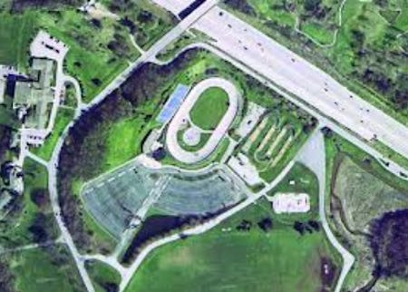
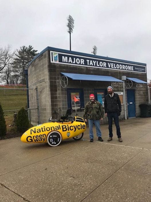
Produced by the US Olympic Committee until 1995, it was held in the years between Olympic Games as a way to develop American athletes. In order to make it successful in Indianapolis, the ISC invested over $100 million in new facilities. These included the Major Taylor Velodrome, the Natatorium and Carroll Stadium.
With the help of 3,000 volunteers and a supportive media, it was a huge success. There were even large crowds at cycling, handball and synchronized swimming events. In fact, a sellout crowd of about 6,150 at the men's 10-meter platform competition is believed to be the largest crowd ever for a diving event in the United States.
For the 1987 Pan Am games, the ISC took things to a higher level. It created an organizing committee called Pan American Ten/Indianapolis (PAX/I) that had eighteen operating divisions, 300 paid staff, and 37,000 volunteers. A massive undertaking, for the 4,300 athletes from 38 countries competing in 30 different sports, it held events at 23 different sites.
Held over a two week period, the games, a broadcast sensation all over the world were opened by vice President George Bush, Sr. As the first and only US city to host the PanAm Games, Indianapolis pulled out all the stops to make them unforgettable. The opening ceremony, for example, was held at the world-famous Indianapolis Motor Speedway. There, they contracted with the Walt Disney Company to produce the largest outdoor entertainment show the USA had ever seen.
In the end, the Pan Am Games brought about $175 million to Indianapolis’s economy. This as the cost to produce them was $30 million - a huge windfall for the city and a powerful endorsement of Hudnut’s vision.
In their aftermath, it was the relationship they formed with the NCAA that would see the NCAA move its headquarters to Indianapolis in 1998. Nor has the Indiana Sports Corporation stopped. By adding professional sports teams, stadiums, arenas and other state-of-the-art facilities, Indianapolis is now recognized as the Sports Capital of the World.
In addition to Hudnut's amateur sports initiative, city leaders had also begun to think that the manufacture of information and not hard goods was the future. For this they knew that would require a different work force of well educated, younger people. But how could they make their city attractive to them? How could they interest them in all the parks the city was busy overhauling?
It was here that landscape developer, Ray Irvin, saw a solution. His thinking was shaped by famed urban studies author/theorist, Richard Florida, who maintained that the kind of people Indianapolis was looking to attract honored the bicycle. They saw it as a potent symbol of identity and status.
In having his listening turned up for what Florida called the ‘young creatives’, he was learning what the needs were of these future drivers of the city he and his group wanted to attract. It was here that he shared Florida’s vision that they would become less reliant on the car in their transportation decisions. He started to lean how their mobility needs were different from those who drove automobiles.
Irvin knew if he could get infrastructure for cyclists built, the smart young people he was looking to bring to Indianapolis would come. He began to wonder what he could do along the edges of the polluted river too shallow for boat traffic that ran through the center of town. Or if there was anything he could do with the many streams that fed it that were strewn with litter, car tires and other debris.
In daring to see a radical new Indianapolis that could reverse the slide it had taken to its being a worn out, contaminated waste land, besides serving the travel needs of young people, he also knew it had to be beautified. It was here that Ray’s thinking was also influenced by George Kessler, the world famous city planner, talked about above. Celebrated for being able to blend natural landscapes with transportation corridors and places where large numbers of people congregate, Kessler’s projects can be found in 23 states, Mexico, China and in 100 different cities.
With the city’s broad expanse of parks as his canvas, as a real life expression of Goethe’s words -
Whatever you can do or dream you can,
begin it, boldness has genius power and magic in it
Irvin drew up the Indy Greenway Master Plan. It would not only access all the new sports facilities (swimming pools, gymnasiums, disc golf, ballfields etc) in the parks, but also serve the transportation needs of the new workforce he and other city fathers foresaw. It was here that he interconnected the learning centers, libraries, parks, all the public places people go on their bikes, with greenways. To help him achieve this, he turned the blight of the undeveloped flood plains needed to control runoff from storm events into even more greenway travel corridors.
Ambitious and massive, his plan required bridges, underpasses, earth moving, building renovation and a gargantuan amount of engineering work. Then his enthusiasm began to find money for it. Irvin set the city of Indianapolis on fire with his vision. Soon, toward the end of making it real, he had many different businesses and people from many walks of life contributing to what he foresaw.
He even had a handful of the local colleges and universities plugged into his excitement (Indianapolis is home to 40 institutions of higher learning, and 31 percent of the city's residents hold a bachelor's degree which is above the U.S. average). Their students were doing a lot of the study and research he needed to be able to prove greenways did not induce crime and other trouble. Their work instead helped him prove greenways united communities and increased property values as they made the turf all along them desirable places to live, work and play.
Through endless meetings with the public at large, local government organizations, property owners and businesses, Ray sold his vision of a greenway filled Indianapolis. Tirelessly, he also worked to get residents interested in reclaiming their waterways. He even went out on many of the countless litter pick up missions he organized.
Being a former politician, Ray was in line to become the Mayor of the City when he chose to build the Greenway plan he felt called to devise instead. Armed with a deep understanding of city bureaucracy, he also knew he had to position the plan he would draw up in such a way that it would take maximum advantage of all of the opportunity in Indy city planning architecture. For example, because of Ray, Greenway alignments are also part of the permitting process in Indianapolis, any future road building has to take them into account.
To keep it funded, growing and maintained, Irvin also called for the building of the very active nonprofit, the Greenway Foundation of Indianapolis. Soon, infected by the desire to build Greenways for themselves, other parts of the state found themselves needing a way to be able to receive donations. As a result, the name of Irvin's charitable organization was changed to the Greenway Foundation of Indiana..
It was an honor to finish the work Olmsted and Kessler started, and even though I saw the unfinished opportunity, it took Indy to realize the unfinished need of their work, I worked to take my vision and instill it in so many others, so they might join the effort and insure its future for another 100 years for Indy’s residents and nature lovers.
Thanks to everyone that joined the vision.
Ray R Irvin
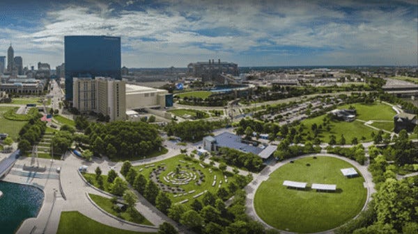
As more and more locals got infected by Irvin’s passion, Indianapolis became more and more of a bicycle playground. The 250-acre White River State Park (WRSP) paradise, for example, now epicentered around the pedal machine, was the result of a total and complete facelift to a blighted landscape as I document in my book "How Indianapolis Built America and How it will Rebuild It with the National Bicycle Greenway.” A charge led by Ray, the public was much involved through many meetings as they helped public officials and landscape developers design the park that resulted.
A world-class state park, recognized as one of America’s top city parks, several blocks from the dead center of the city, White River State Park extends for almost a mile on both sides of the now 600-foot wide (for flood prevention, its width was doubled by the Army Corps of Engineers in 1917 ) White River. To create it, as many as 50 businesses were eviscerated and 14 streets were either removed or altered.

Now, in the main part of the park, the nearby Indy Canal narrows into a stream that falls off as a waterfall near where the the old National Road Wood Covered Bridge of 1834 left land to cross the White River. Along the way it passes through the Celebration Plaza & Amphitheater and Governor’s Lawn. At the park, one can also find - the Eiteljorg Museum of American Indians and Western Art, surrey and trike rentals, a community garden, a Visitor’s Center, the Indiana State Museum, an IMAX Theater (inside the Indiana State Museum – park operated), the 1914 Washington St. Bridge (now a car free Promenade), the restored Indianapolis Waterworks of 1870 and a world class music stage. Capable of accommodating up to 50,000 people, it is all this that now anchors the most bikeable downtown in America.
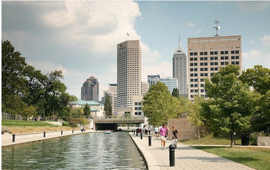
The nearby, 1.5 mile long, Indy Canal, complete with water walls, fountains, outdoor dining, paddle boats, kayaks, gondolas and water foul, etc, etc, is surrounded by a bike path which also finds two, three and four wheel bike surreys on it.
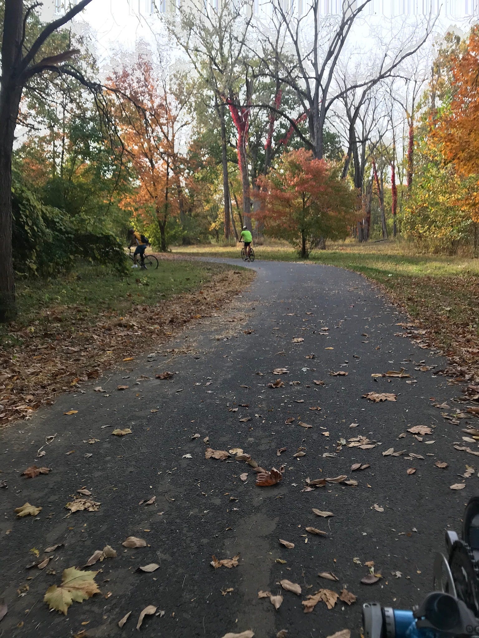
Headed away from White River State Park in a different direction, there is the White River Greenway trail. On your way to the short, Central Canal Towpath, easily one of the top Greenway stretches in all the world, you will ride past the recently failed Emrichsville Dam of 1899. Behind you, there is the old Bush baseball stadium that, complete with its old lighting towers, looks a lot like it did from 1931 to 1996 but now serves as a condominium lodging complex. It was here in 1952, that a young Hank Aaron played his first ever professional baseball games.

After the baseball park, on the other side of 16th St., on one side of the trail is a golf course, Taggart Memorial, an outdoor performing arts amphitheater.

Next to Taggart is enormous Riverside Park filled with play structures, ballfields endless lawns, an activity center, picnic shelters, basketball courts, even horseshoe pits, etc. On the other side of the trail and the lightly traveled road, is Lake Indy. A boat launch for the White River, it is a cozy little park with picnic tables and barbecue pits.
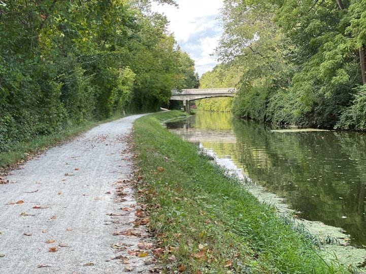
After crossing over 29th St at Riverside High School (located in the old Naval Armory Building), once you snake behind it and through the condominium village, you will be on the Central Canal Trail. Where it crosses over White River Parkway, 6/10 of a mile after the high school, a slice of bicycle heaven begins. Here, on crushed limestone, the old Central Canal Towpath will make the world melt away. It travels for three miles along along an historic, 19th century, man-made tree-shaded waterway. Calm and flat, it even saunters through a part of the beautiful Butler University campus as well as Newfields. Newfields is a 152-acre indoor/outdoor nature preserve. Its campus includes a wooded lake, hiking trails, museums, and gardens, etc.
The Fall Creek Trail travels along another waterway that feeds the White River, Fall Creek, for ten miles to 1700-acre Fort Benjamin (aka Harrison State Park). It can be accessed from Burdsal Pkwy an extremely wide, four block long, tree shaded road that leaves the Taggart Memorial. Its smooth asphalt winds through an enchanted wonderland of trees and thickly forested lands to get there. The park itself has huge playing fields, cabins, campsites, even a historic hotel for overnight lodging. There are also picnic grounds, a war history museum, a singe-track trail for mountain biking, six hiking trails, an 18-hole golf course, and an interpretive center
On the south west side of downtown, the Pleasant Run Trail, accessible from the Cultural Trail, travels through the rolling hills of tree covered Garfield Park. At 128 acres, Garfield Park is the oldest park in the city of Indianapolis. Designed in 1881 by the same George Kessler who influenced Ray Irvin, it follows the lines of two creeks. Its features include the first conservatory building in America, an amphitheater, sunken gardens, fountains, picnic areas, two arts centers, tennis courts, ball fields, horseshoe pits and a huge pool complex, etc.
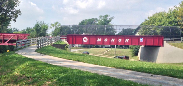
Even where there is no water, there are world class bicycle paths. The Monon Trail travels from the Bottleworks (a reconverted, massive Coca-Cola bottle manufacturing plant), an exciting new shopping district at the edge of downtown Indianapolis, for 26 miles to the town of Sheridan. It has become the gold standard by which other trails are measured.
A reconverted rail bed, it is a paved linear art park with tastefully positioned statues, community murals, paintings and metal sculptures - there is even a network of pipes painted on the side of a utility substation. Other wall paintings along the way adorn a freeway underpass and the sides of a few warehouse buildings. Strategically positioned bridges take you over creeks and busy roads. Many of the backyards through which it passes have been landscaped so they blend in with the trail.
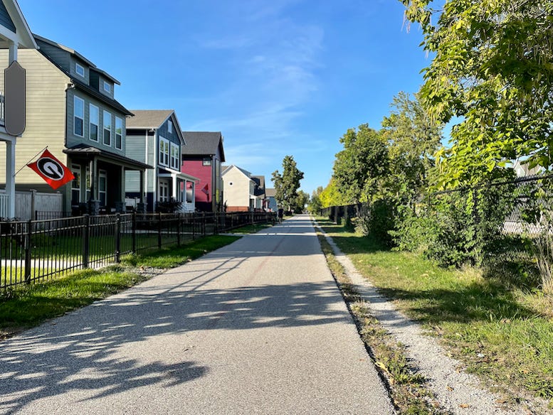
The Monon has even spurred a building boom. Many parts of what was once a blighted part of town are now like premium, beachfront property for the homes built nearby. Those constructed right next to it have small front yards that look out on the trail.
And then there is the only downtown Greenway in the world, the Indianapolis Cultural Trail. The catalyst for this book, it even has its own chapter here. I have cycled in cities large and small all over America and the world. And nowhere have I found a more bikeable downtown than the one here in Indianapolis. Not even close. And all of this is due to the fact that this history laden city <NBG Histories we developed as we formulated the Cultural Trail video> has the only functional network of central business district bike paths on the planet.
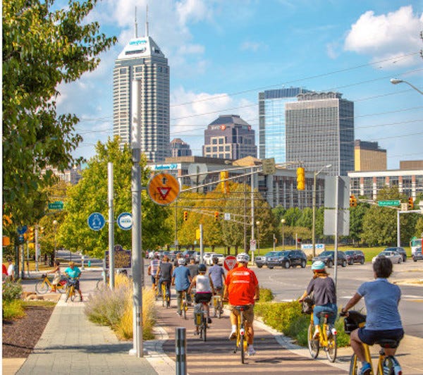
Called the Indianapolis Cultural Trail (ICT), from it, a plethora of Greenway trails and other cycling opportunities branch out from its 8-mile (soon to the 10-mile) core. It has become a breeding ground for cyclists young and old and has reenergized a once dying business district with a new explosion of energy. This as it has brought new life to the entirety of what used to be a tired Rust Belt city. It has caused a building boom on what were vacant lots on the downtown trail and hugely increased the value of all the property along it
On specially groomed sidewalks, as business is being done several yards away, the way the curbs are cut and the lights are timed, as a cyclist, you feel you are wanted here. Or, as Ray Irvin says, “the ICT is a showcase of how the businesses of the future will all operate – car visits will not be encouraged, but human powered ones will.” As the genuine prophet that Ray is, he says that to be successful in the imminent future, your storefront will have to be on a people powered throughway – it will have to be bike friendly.
On the ICT, the smooth surface of a handsome, red brick has replaced the concrete sidewalks that pass ten or so feet away from the front doors of a myriad of eateries, hotels, drinking establishments, coffee and thrift shops and fitness facilities. Along it one can also find a bike shop, and hardware and grocery stores.
Add beautiful landscaping and tastefully designed interpretive signage that call out everything from Civil War battles to historical events that took place at the locations they herald and you will feel drawn into a keen awareness of your surroundings as time slows down. You will also sense what we would like to see become a nationwide reality.
In going forward with our plan to plant the seed for Cultural Trails, we need to firmly establish Indianapolis as the Top Biking City in America. We need cyclists from all over the country to want to come here to prove this for themselves. Whereupon, as they go back to their communities seeking to follow the example we have set, this will help us lay the foundation for replicating Cultural Trails in all 19 of our other NBG Anchor Cities.
In order to attract bike visitors to our city, to want to fly with their bikes to Indianapolis International Airport, the top rated airport in North America, we need to show what Indianapolis has to offer cyclists. One place we can start is by doing audio/visual podcasts of the internationally acclaimed bicycle infrastructure here.
To get the highest quality product possible, we might do well to see if we can a film crew to showcase our greenways. A short documentary of the Major Taylor Velodrome complex would also be an important addition.
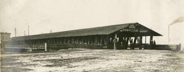
In my book about Indianapolis, I talk about the 1834 National Road wood-covered bridge (pictured above) that connected the Indianapolis riverfront to the frontier of the West. I also discuss the Washington St bridge that replaced it in 1870. Now a Car Free esplanade, on it we had hoped (until Covid 19) to receive the 2021 National Mayors' Ride as a part of the city’s Bicentennial.
In 1913, the Washington bridge had been washed away by a massive flood that put much of the city under water. Rebuilt and made longer, It re-opened in 1916 after, the Army Corps of Engineers widened the river here. From 1915 to 1917 they also built massive levees to help contain more water in the wider river that resulted.
The original wood covered bridge entered the unknown of the frontier at this location. Because of its significance and the fact that it was so heavily used, I have written a chapter that shows how, because of it, Indianapolis is the real Gateway to the West, and not St Louis.
One of the reasons I have pumped so much energy into this city’s history, is because I want Indianapolis to be seen as the genuine transportation leader it is and always has been. In reinvigorating/transforming itself from the tired rust belt city that it had become (for a decade and a half) with Greenways, the result Indianapolis has achieved is something we need to be celebrating with great excitement on a national level.
By showing it as the transportation leader it long has been, in now embracing its greenways, its cyclists are also honored. It is this example that needs to also be replicated from one coast to the other.
All of the claims I am making about Indianapolis are all well documented in the book I have written about this much underrated city. If we are going to change America’s transportation habits as a way to heal the planet, with its preponderance of Greenways, Indianapolis must once again lead the way!
Once it is established as the genuine Gateway to the Frontier, since it is the Crossroads of America where half the nation is within a day’s car drive, its profile as an important must visit city will skyrocket. Soon, large numbers of people will feel the need to experience for themselves the history that proliferates here. And as they do, they will feel called to enjoy the two-wheel wonder that abounds in what is more and more becoming accepted as America’s top bike city. Toward that end, the argument history scholars helped me to make in proving that it was Indianapolis that opened up the West, and not St. Louis, that will give added authority to Indy’s greenways. On center stage, Indianapolis will be able to show the power greenways have to re-energize business centers as well as build community .
In 1902, when the original wood covered, National Road bridge over the White River was dismantled, the city lost a lot of its muscle. In not being able to prove that it was the first to go where there were no roads, it lost its ability to call itself a leader. In the name of progress, it had destroyed its connection to a past that led the way in settling the West.
In the 1960’s, when St. Louis was busy campaigning for federal dollars to rebuild its waterfront (and change its image from being known as Mound City) by re-branding itself as the Gateway to the West, Indianapolis was not even considered. It had nothing to show for itself.
In yielding the Gateway moniker to St, Louis, Indianapolis got pushed off to the side. Once former Indiana state historian, Brigette Cook Jones, and I discovered the wood-covered National Road bridge, that even local history has expunged from the record books, I knew we had made a huge breakthrough. I knew its memory had to celebrated. It would help Indianapolis shine as the transportation leader it always has been.
Nor do I make this statement lightly. With the help of well qualified others, once we discovered this expunged bridge, it set me off on a path to back up what I felt it signified. I pumped a lot of time into learning what I could about it. As such, what has resulted is the ironclad argument I have made in my book about Indianapolis being the Gateway to the West and not St. Louis.
What I have proposed has been accepted by local and state historiographers, as well as local business leaders. Once this becomes an accepted notion beyond city and state confines, more and more people all over this Nation will pay attention to the leading edge/trendsetting direction that Indianapolis is moving in with its Greenways.
In terms of how the original bridge was used, in 1834 it enabled the National Road from Washington, DC to reach the frontier of the West on the other side of the White River. At one point, there were as many as 90 wagons on it an hour.
At the very least, there needs to be an historical marker along the river’s edge on the black railing between the water and Celebration Plaza & Amphitheater in White River State Park. A nominal expense, this can be done now!
At present, there is absolutely no trace of the original bridge. Not even any of its original substructure, its piers. Nothing. It has completely vanished.
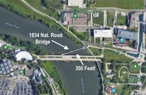
In August of 2021, however, since I cross the esplanade daily, I discovered what I am almost certain is the landing pier for where it reached the western shore. Located 350 feet from where we think it left the Eastern shore, is a concrete encasement next to the foundation for the present bridge. I note 350 feet because that was the spec called for when the original bridge was put out to bid in the 1830’s.

It took Indiana state historian, Brigette Cook Jones and I, poring though old newspaper clippings for us to realize what the water crossing was that appeared in old 19th Century Sanborn fire insurance maps - the one that came in on an angle per this image.
Its history was nowhere to be found on the world wide web. This after scouring the Internet and even asking for off-line help from the local and state history societies. Seems back then, it was a lot more convenient to just let people think the bridge that came 36 years later, in 1870, was the original water crossing out there. This with no mention of the fact that even what is there now, the esplanade, was rebuilt in 1902 (when the wood covered bridge was dismantled by the city) and in 1914 (after the great flood of 1913).
There are things here city leaders can do to help Indianapolis get the credit it deserves. It can be proactive. It can start by putting a mural on the back of the newly constructed music stage in White River State Park adjacent to the White River. Such a mural would be a few hundred feet from the old National Road bridge. It could read:
Indianapolis, the Gateway to the Frontier
By using the word ‘frontier’, St Louis can keep its ‘Gateway to the West’ moniker.
In time, a replica of the 1834 wood covered bridge needs to be built that honors the outsized part it played in helping to settle the West. This could even take the form of moving an abandoned wood covered bridge to this location. In fact there is no shortage of such structures in Indiana.
About 70 miles from Indianapolis, every Fall, there is the Parke County Covered Bridge Festival. This annual event showcases the county’s 39 historic covered bridges. This could be a great window shopping venue for city fathers and mothers.
Such a reconstructed acquisition, would be a powerful tourist draw and could house some of the history about the magical riverfront (given a whole chapter in my book how about how Indianapolis built America) as well the nearby site of McCormick’s cabin (150 feet from the bridge/esplanade). In 1820, John McCormick became the first settler in Indianapolis at the location a boulder marks in front of the NIFS and NCAA buildings.
With a transportation legacy that opened the frontier where there were no roads, with its National Road bridge, Indianapolis set in place the momentum that would civilize all of America. Besides all of the many other ways Indianapolis led the way in early transportation, as we showed you above, here now over a century later, Indianapolis has returned to the leading edge as the Greenway Capital of the World,
Cities from all over the globe come here to learn how to replicate such success in their own locales. This is especially true for the world’s first and only downtown Greenway, the Indianapolis Cultural Trail that has made Indianapolis the most bikeable downtown on Planet Earth! It is the ICT formula we want to replicate in all 19 of our other NBG anchor cities, as they as well celebrate the ability of the pedal machine to greatly enrich themselves.